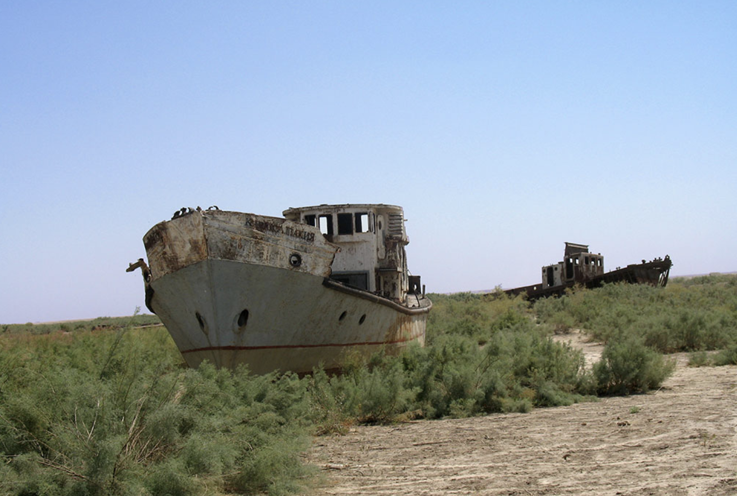
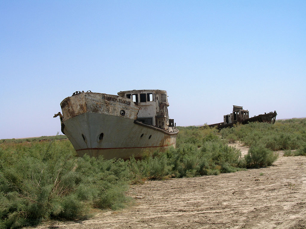
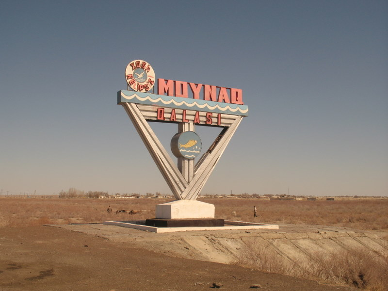
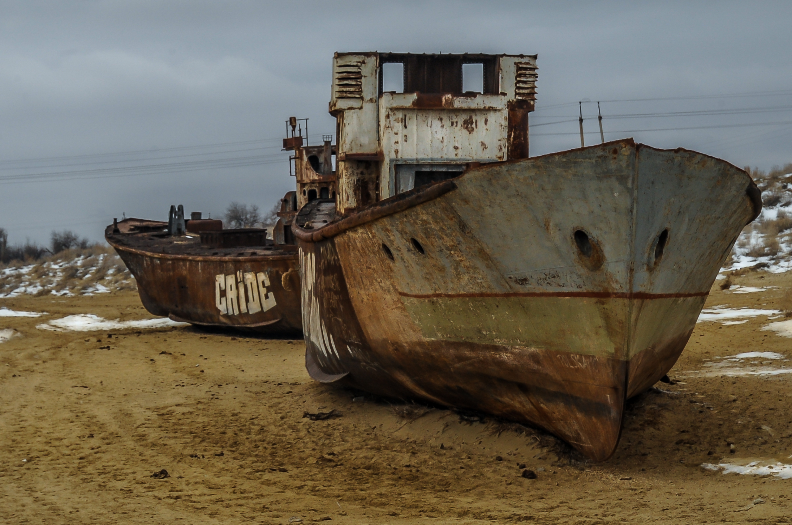
The Aral Sea covered 26,000 square miles in 1960. Today, more than 90% of it is gone. The fishing port of Moynaq, Uzbekistan now sits over 90 miles from the nearest water — its rusting fleet of ships permanently stranded in what is now the world’s newest desert.
In 1960, the Aral Sea was the fourth-largest lake on Earth — covering 26,000 square miles between Kazakhstan and Uzbekistan, roughly the size of Ireland. Soviet maps showed a vast blue body of water sustaining a fishing industry that employed over 40,000 people.
If you look at the same region on a map today, the Aral Sea has essentially disappeared. What remains is approximately 10% of the original lake. The cities that once sat on the shores now sit dozens or hundreds of miles from any water at all. Their fishing fleets are still there, but they’re stranded in sand.
1: The fourth-largest lake on Earth
In 1960, the Aral Sea covered 68,000 square kilometers (26,000 square miles) — making it the fourth-largest lake on Earth. The lake supported a fishing industry that employed approximately 40,000 people. Native fish species included bream, carp, perch, and others. The river deltas around the lake produced 500,000 muskrat pelts per year. Cities along the shoreline, including Moynaq in Uzbekistan and Aral in Kazakhstan, were thriving fishing ports with industrial-scale fish-canning factories. Soviet families vacationed at the lake’s beaches.
2: How the disaster started
The Aral Sea was an endorheic lake, meaning it had no outlet to any ocean. Water flowed in via two major rivers (the Amu Darya from the south and the Syr Darya from the north), then either evaporated or seeped into the surrounding land. For thousands of years, the system had been roughly in balance. In the 1960s, Soviet planners decided to use the river water for cotton irrigation instead. The plan was to divert the Amu Darya and Syr Darya through enormous canal systems to feed cotton plantations in Uzbekistan, Turkmenistan, and Kazakhstan. The cost — drying out the Aral Sea — was understood by Soviet officials but considered an acceptable tradeoff.
3: The cotton plan worked
By the 1980s, Uzbekistan had become one of the world’s largest cotton exporters. Soviet textile production grew dramatically. The economic logic that planners had used to justify the project produced exactly the predicted results. The unintended consequences were far worse than anyone had anticipated. Between 1960 and 1998, the Aral Sea’s surface area shrank by 60% and its volume by 80%. By 1997, only 10% of the original lake remained.
4: The lake split in half

In 1987, the lake split into two separate bodies of water — the smaller North Aral Sea (in Kazakhstan) and the larger South Aral Sea (mostly in Uzbekistan). The South Aral then split further into eastern and western basins. In 2014, the eastern basin disappeared entirely. Today, only the North Aral Sea (in Kazakhstan) and a small western lobe of the original South Aral Sea (in Uzbekistan) still hold water. Salinity rose dramatically — from approximately 10 grams per liter in 1960 to 376 g/L by 1990. For comparison, ocean water is about 35 g/L; the Dead Sea ranges from 300 to 350 g/L. The Aral Sea had become more saline than the Dead Sea.
5: The fishing industry died

The fishing industry that the lake had supported collapsed. By the late 1990s, the South Aral was too saline to support any fish species. The native species had gone extinct in the wild. The flounder that the Soviets had introduced as a salt-tolerant replacement species also died as salinity continued to rise. The muskrat-trapping industry in the river deltas, which had once produced 500,000 pelts per year, ended completely. Moynaq’s population dropped from a peak of 30,000-40,000 to approximately 13,500. The water’s edge is now over 150 kilometers (about 93 miles) away from the town.
6: The ship graveyard of Moynaq
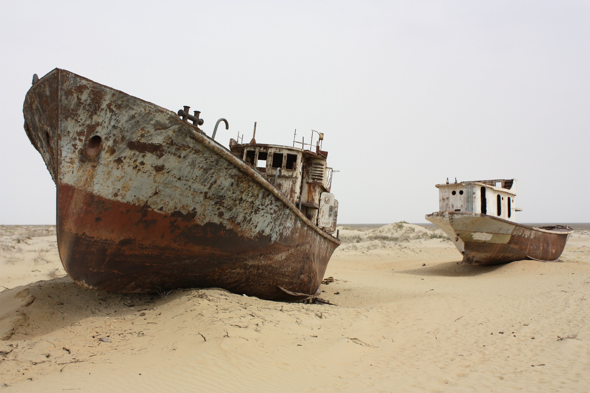
The ship graveyard at the edge of Moynaq — a row of rusting fishing vessels permanently grounded in what was once the harbor — has become one of the world’s most photographed monuments to environmental disaster. The vessels were left in place when the water disappeared faster than the boats could be moved or salvaged. Today, the rusting hulls sit stranded in the sand, with informational signs and a small museum nearby. Bactrian camels can be seen wandering between the ships. The town’s entrance sign still features a fish — a relic of when fishing was the entire local economy.
7: The toxic dust storms
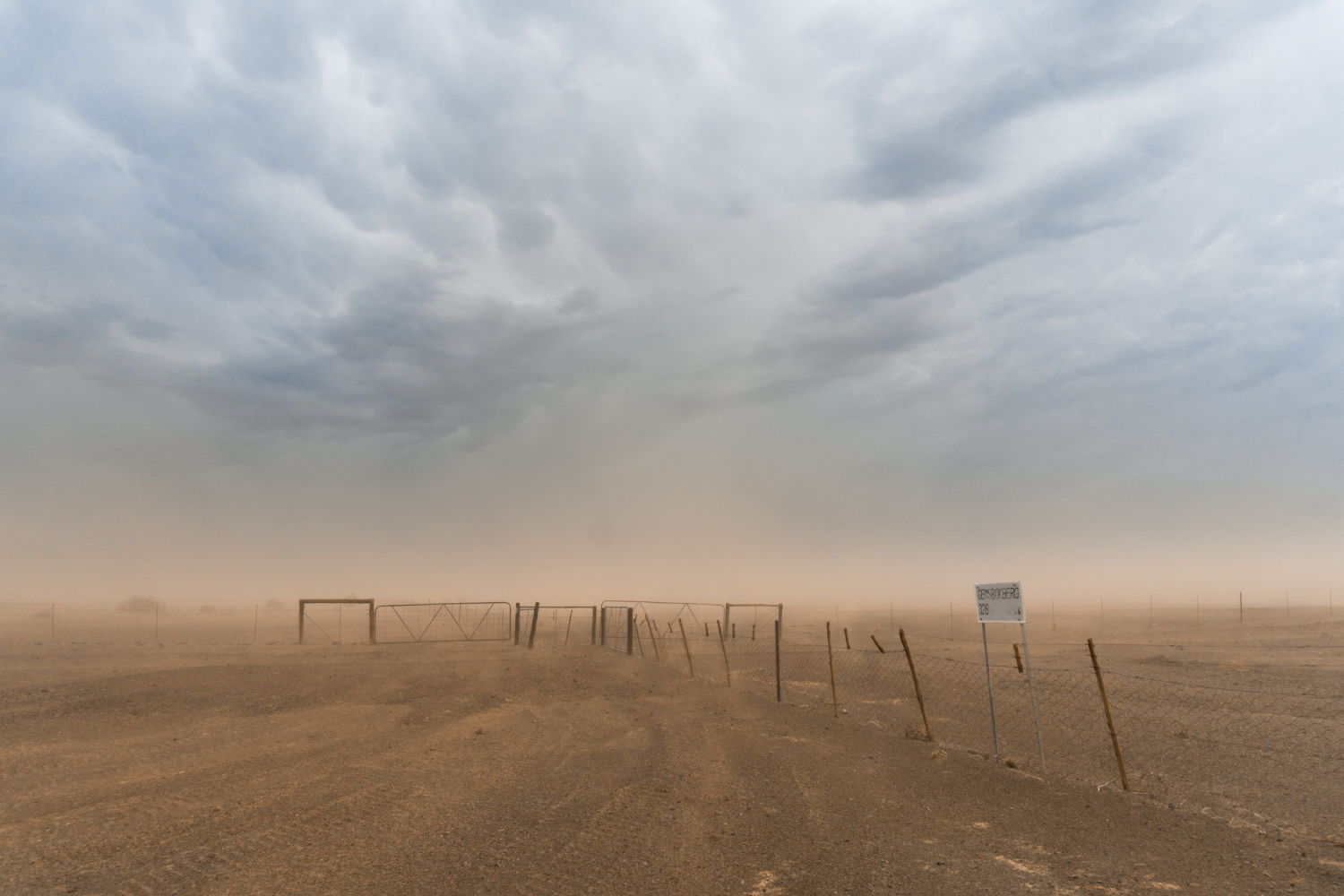
When the Aral Sea evaporated, it didn’t just leave behind dry sand. The seabed had accumulated decades of agricultural runoff from the cotton fields upstream — pesticides, herbicides, defoliants, and chemical fertilizers. As the water evaporated, these chemicals concentrated in the remaining seabed. Strong winds blowing across the dried seabed regularly pick up this toxic mixture and carry it across the surrounding regions. Dust storms have been documented carrying Aral Sea seabed material as far as the Arctic glaciers, the Norwegian forests, and the Atlantic Ocean. Local residents inhale this dust regularly, with documented impacts on respiratory health, cancer rates, and infant mortality.
8: The bioweapons island that no longer exists
In 1948, Soviet authorities established a top-secret biological weapons research and testing facility on Vozrozhdeniya Island in the center of the Aral Sea. The list of biological agents tested there is genuinely terrifying: anthrax, plague, smallpox, Q fever, tularemia, brucellosis, typhus, botulinum toxin, and Venezuelan equine encephalitis virus. In 1971, weaponized smallpox from the facility reached a nearby ship through atmospheric drift. The crew brought the infection back to the city of Aral, where 10 people were infected and three died. A massive vaccination effort involving 50,000 inhabitants prevented a wider outbreak.
9: The bioweapons facility became accessible
The bioweapons base was abandoned in 1992 following the Soviet collapse. As the Aral Sea continued to shrink, Vozrozhdeniya Island gradually became a peninsula, and then in 2002 it became fully connected to the surrounding mainland. The biological agents stored at the facility — particularly the anthrax spores, which can remain viable in soil for decades — became theoretically accessible to anyone willing to walk across what had been seabed. In 2002, a joint U.S.-Uzbekistan operation funded by the Pentagon’s Threat Reduction program decontaminated the major anthrax burial sites. The remediation removed most but not all of the biological hazards.
10: Kazakhstan’s recovery effort
Kazakhstan has made meaningful progress on restoring its portion of the lake. The Kokaral Dam, completed in 2005 with World Bank funding, separates the North Aral Sea from the dried-out South Aral and prevents the remaining water from continuing to flow southward and evaporate. The dam has produced significant results: the North Aral’s surface area increased from 2,550 square kilometers in 2003 to 3,300 square kilometers by 2008. Over 15 species of fish have returned to the North Aral, and small-scale commercial fishing has resumed. Approximately 5,000 people have returned to the area for fishing-related work.
11: Uzbekistan won’t follow suit
Uzbekistan, by contrast, has shown essentially no interest in restoring the South Aral Sea. The Uzbek government continues to divert the Amu Darya for cotton irrigation, prioritizing the cotton industry that the original Soviet planners established. The South Aral seabed has become an active oil and gas exploration zone, providing a different economic rationale for keeping the area dry. The result is asymmetric: the northern portion of the lake is gradually being recovered, while the much larger southern portion is being permanently treated as desert and resource extraction land.
12: Visiting the disaster
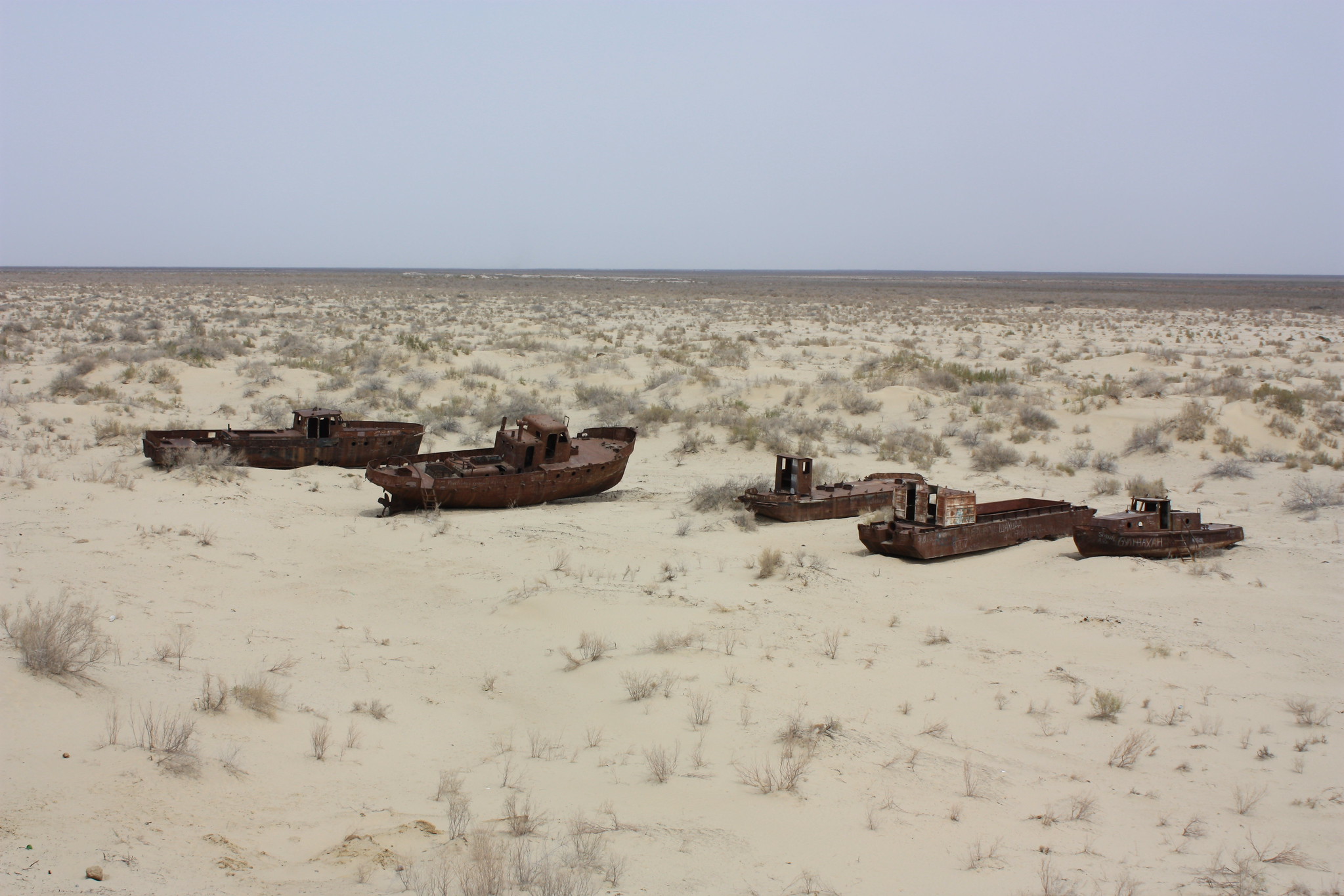
Despite — or perhaps because of — the scale of what happened, the Aral Sea region has become a destination for what’s now called “disaster tourism.” The most-visited attraction is the Moynaq ship graveyard. Tour operators run multi-day excursions from Khiva, Nukus, and Tashkent that include the ship graveyard, drives across the dried seabed to reach the current South Aral shoreline, and overnight stays in traditional yurts. In a strange final chapter, Moynaq has also become the unlikely host of an annual electronic music festival called Stihia — Central Asia’s largest. Held in the desert near the abandoned ship graveyard, the festival has drawn international attention. The juxtaposition of warehouse-style techno music in the silent desert next to permanently-grounded ships is one of the strangest tourist experiences available anywhere.
13: What this represents
The Aral Sea was once the fourth-largest lake on Earth. Now it’s a desert with rusting ships in it. The transformation took less than 60 years. The rebuilding, where any rebuilding is happening at all, is measured in centuries. For the regions surrounding the dried seabed, the consequences will continue for at least another century. The toxic dust will continue blowing. The contaminated seabed will continue producing health effects. The economic base that the lake once supported will not return. Standing on a dried seabed where ships still rust in the sand, looking out at a horizon where there used to be water, is genuinely difficult to describe — but it offers something few destinations can: a direct, visible record of what the modern world is capable of doing to itself when economic incentives line up the wrong way.