In August 2006, Fredrik Fransson and his uncle were sailing the 38-foot yacht Maiken from Tonga toward Fiji when they encountered something they couldn’t explain — the ocean had turned to stone. What they discovered over the next 48 hours, documented in real-time on their blog and later confirmed by NASA satellite imagery, was something fewer than 10 humans in recorded history have witnessed firsthand. The Smithsonian’s Global Volcanism Program later cited their account as the primary documentation of the entire event.
1: A Swedish Sailing Family in the South Pacific
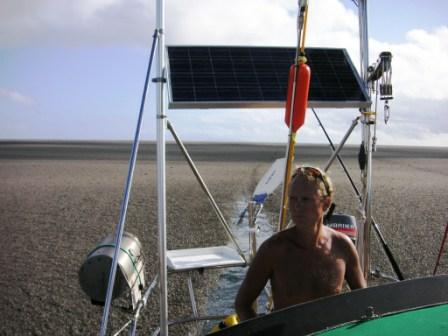
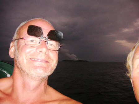
In August 2006, Fredrik Fransson, his uncle Håkan Larsson, and their crew were aboard the 38-foot yacht Maiken, sailing the South Pacific. They had been at sea for years, having sailed from Sweden across multiple oceans on what was supposed to be an extended cruising adventure. By August 11, they had departed the Vava’u Islands in Tonga, bound westward for Fiji — a journey of approximately 500 nautical miles across what should have been routine open ocean.
The route they had chosen was well-traveled by South Pacific cruising sailors. The weather forecasts were favorable. Their charts showed the area as deep open water with no significant hazards. They had no reason to expect anything unusual.
Fransson noted later that they had departed on a Friday — violating the old sailor’s superstition that “you should never leave on a Friday.” He would later observe that “the sea turned to stone — it is hard to get a stronger sign than that.”
2: The Water Was the Wrong Color
The first sign that something was wrong came as the Maiken sailed roughly 20 nautical miles west of the Vava’u Islands. The water, normally the deep blue characteristic of the open South Pacific, had begun to change color.
“The first thing I noticed as we set out from the Vava’u Islands in Tonga was that the water was the wrong color,” Fransson later told Discover Magazine for their feature on the event. “Instead of the familiar deep blue of the open ocean, the waters surrounding the Maiken were lagoon green.”
For experienced sailors, water color in the open ocean is one of the primary visual indicators of conditions. Deep blue indicates open ocean depths. Greens and lighter colors typically indicate shallow water near land, sediment, marine life concentrations, or unusual conditions. Lagoon green water hundreds of miles from the nearest landmass made no sense.
The crew continued sailing west, watching the water carefully, trying to understand what they were seeing.
3: Brown Streaks in the Water
The next stage came roughly five miles further along. The water began to develop visible streaks of brown material on its surface. The streaks looked grainy and irregular.
Fransson’s first interpretation was the most plausible: an oil spill, possibly from a passing ship illegally cleaning its tanks at sea. This was unfortunately not uncommon in the South Pacific shipping lanes, and the brown discoloration was consistent with petroleum contamination.
“First we thought that it might be an old oil dumping,” Fransson recorded in his blog at the time. “Some ship cleaning its tanks.”
But as they continued, the streaks became larger and more frequent. And then they noticed something that made the oil spill theory impossible: the streaks contained solid objects.
4: Floating Stones
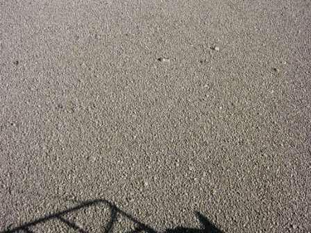
Mixed in with the brown streaks were what appeared to be rocks — irregular brownish objects, roughly the size of fists, floating on the water’s surface.
This was, by any normal understanding of physics, impossible. Rocks don’t float. The South Pacific is one of the deepest ocean regions on Earth, with the seafloor in places dropping miles below the surface. Solid rocks shouldn’t be appearing in the middle of nowhere, and they certainly shouldn’t be floating.
The crew was now genuinely curious. They redirected the Maiken to investigate more closely. Their blog entry from this moment captures the building sense of bewilderment: they were sailing toward something that didn’t make sense, trying to understand what they were seeing.
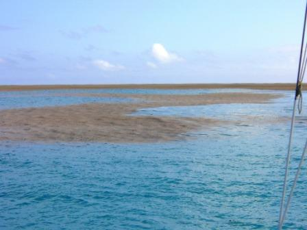
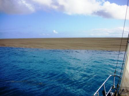
5: A “Beach” in the Middle of the Sea
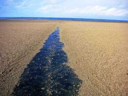
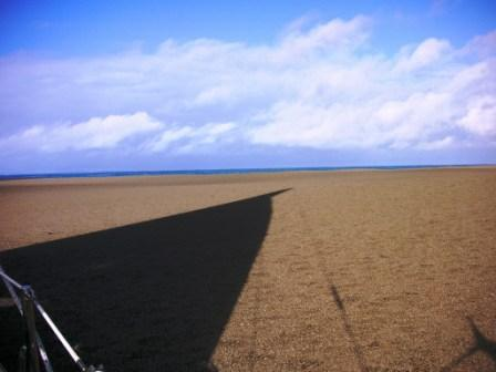
What the crew encountered next defied easy description. As they approached the source of the floating rocks, they found themselves looking at what appeared to be a beach — a vast expanse of stone-covered surface stretching across the ocean as far as they could see.
“We looked out, and in front of us it was as if there was no more sea,” Fransson told Discover Magazine. “It was like the Sahara, with rolling hills of sand as far as the eye could see.”
This wasn’t a sandbank or shallow water — it was a continuous mat of floating material covering the ocean’s surface. The Maiken was looking at what oceanographers call a pumice raft, though the crew didn’t yet have the terminology for what they were seeing.
The decision facing the crew was substantial: turn back and avoid this unprecedented obstacle, or sail through it to investigate. They chose to sail through.
6: Sailing into the Stone Sea
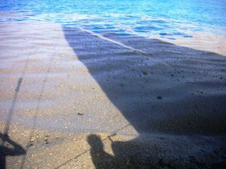
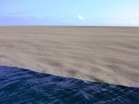
The decision to enter the pumice field nearly proved disastrous. Within seconds of motoring into the densely packed material, the Maiken slowed dramatically — from seven knots to just one knot.
The thin layer at the edge of the field was pushed aside by the bow wave. But as the boat entered the solid central area, the pumice began piling up around the hull. As Fransson described it, the material “behaved like wet concrete” and “looked like rolling sand dunes as far as the eye could see.”
The crew became absorbed in photographing what they were seeing, momentarily forgetting that they were in active danger. As Fransson recorded: “We were so fascinated and busy taking pictures that we plowed a couple of hundred meters into this surreal floating stone field before we realized that we had to turn back.”
The realization came too late to easily reverse. The Maiken was now stuck in a sea of stone with limited maneuverability.
7: The Engine Failure
As they attempted to back out of the pumice field, a more immediate crisis emerged. The Maiken‘s engine — a Yanmar diesel — uses seawater for cooling. The cooling system depends on continuous water flow drawn through intake filters at the boat’s bottom.
The pumice had clogged the cooling system intake filters. The engine stopped producing cooling water. Without cooling, a diesel engine can suffer catastrophic damage in minutes — potentially leaving the boat with no propulsion in a situation where wind alone might not be sufficient to escape the pumice field.
Fransson recorded the moment of realization in his blog: “Just as we came out of the stone field and entered reasonably normal water we noticed that there came no cooling water from the engine. Not surprising, really. After cleaning the water filter the Yanmar diesel started again. Thank God! Without wind we would have been stuck in a sea of stone if the motor had failed.”
The crew had narrowly escaped being trapped indefinitely in floating pumice, hundreds of miles from the nearest land, with no propulsion and uncertain rescue prospects.
8: The Decision to Investigate Further
Most sailors, having experienced what the Maiken crew had just survived, would have prioritized getting away from whatever was producing the pumice as quickly as possible. The crew of the Maiken did the opposite.
After cleaning the engine filters and confirming the Maiken was undamaged beyond some scraped paint along the waterline (the boat had ablative bottom paint specifically designed to wear away in such circumstances), they decided to anchor for the night in nearby Vaiutukakau Bay outside Vava’u and wait until morning to investigate.
They believed — correctly, as it turned out — that what they were seeing must be the product of a volcanic eruption. They didn’t know its location or extent, but they wanted to find it.
The next morning, August 13, 2006, they received radio confirmation that an eruption was indeed occurring somewhere in the area, but the vent and extent remained uncertain. The Maiken set course toward the suspected location.
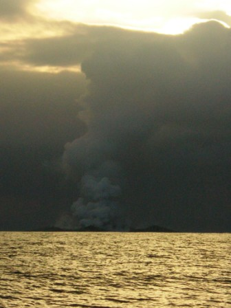
9: The Cloud That Wasn’t a Cloud
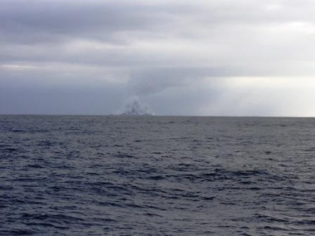
As the Maiken sailed south on August 13, the crew noticed something on the horizon. Among the typical scattered clouds of the South Pacific, one cloud stood apart — taller, darker, and somehow different.
“Often in the South Pacific you have clouds on the horizon, but this time there was one that stood out,” Fransson recalled.
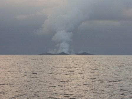
As they approached, the cloud’s true nature became clear. It wasn’t a meteorological cloud — it was a volcanic plume rising from the ocean surface. Somewhere ahead of them, a volcano was actively erupting, sending material thousands of feet into the sky.
Their charts showed only a submarine seamount in this location — a feature called Home Reef that lay below the ocean’s surface. Whatever was producing the plume wasn’t supposed to exist as a visible feature. It was something new.
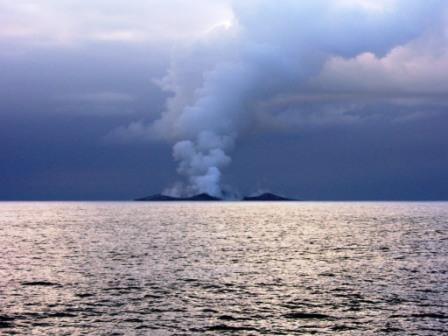
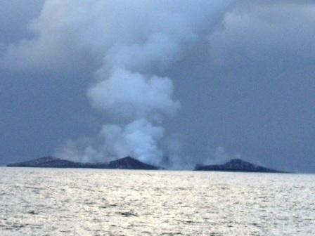
10: Witnessing the Birth of an Island
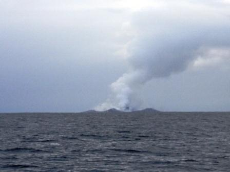
What the Maiken crew encountered as they approached Home Reef would later be documented as a once-in-a-generation observation: the active formation of a new island in the open ocean.
“It was kind of a smoldering, smoky stuff. It looked like coal,” Fransson told Discover Magazine. “And when there was an eruption, we could see the new material piling up on it.”
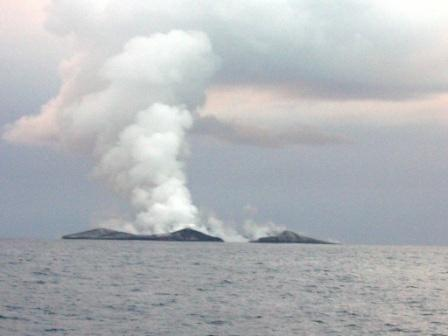
The Smithsonian Institution’s Global Volcanism Program later compiled the official documentation, drawing primarily on the Maiken crew’s observations: “Multiple peaks forming a crater open to the sea on one side were visible, and it looked like it was ‘made of black coal.'”
The crew sailed within 2.8 kilometers of the active volcano (later precisely located at 18°59.5’S, 174°46.3’W). At this distance, they could observe the eruption sequence directly: massive black pillars shooting upward toward the sky, particles raining down across substantial areas, and new land accumulating one explosion at a time.
11: The Photographs That Changed Volcanology
The crew of the Maiken did something that would prove scientifically invaluable: they took photographs throughout the entire experience and documented everything in their blog.
Their photos showed the pumice rafts, the discolored water, the volcanic plume, and ultimately the new island itself in its earliest stages of formation. These images, posted to Fransson’s blog at yacht-maiken.blogspot.com, were the first detailed documentation of the entire event.
When the crew posted their observations and photos online, scientists noticed immediately. Greg Vaughan, a geologist with NASA’s Jet Propulsion Laboratory, told Discover Magazine: “We decided right then that we needed to get in there and get some satellite data.”
NASA’s ASTER and MODIS instruments captured satellite imagery of the new island and surrounding pumice rafts. The satellite data, combined with the Maiken‘s ground-truth photos, provided what oceanographers and volcanologists described as unprecedented documentation of an underwater eruption that produced a new visible island.
12: The Scientific Value of the Observation
Volcanologist Scott Bryan of Kingston University in London immediately began organizing a research expedition to the island. As he later explained, undersea eruptions probably occur dozens of times per year — but they typically happen in remote locations or at extreme depths, so they’re rarely witnessed by humans.
Bryan and other researchers raced against time. Many new volcanic islands are ephemeral — lasting only weeks or months before being washed away by wave action. As Bryan noted: “Ultimately, it’s a battle between the frequency and volume of eruptions and the wave action taking it back down to sea level.”
The type of material erupted affects island longevity. True lava forms enduring structures (like Surtsey in Iceland, which formed in 1963 and remains exposed today). Islands made primarily of pumice and ash — like Home Reef’s new island — are quickly eroded by waves.
When Bryan finally reached the site in February 2007, he found that the new island, originally over a tenth of a mile square, had already nearly washed away. The window for direct scientific observation had closed within months.
13: The Pumice Raft’s 1,600-Mile Journey
The pumice raft the Maiken had encountered didn’t stay near Home Reef. The buoyant volcanic material drifted across the South Pacific for months, eventually traveling more than 1,600 kilometers.
By December 2006, pumice from the eruption had reached Vanuatu. By April 2007, eight months after the eruption, pumice from Home Reef washed up on beaches in Queensland, Australia — over 2,000 miles from where it originated.
The pumice didn’t travel alone. Scott Bryan’s research showed that during the months at sea, the floating rocks had been colonized by barnacles, corals, algae, oysters, tube worms, and other marine organisms. The pumice rafts had become floating habitats, transporting marine species across vast distances.
This discovery had broader implications. The diversity of the famed Great Barrier Reef in Australia, Bryan suggested, may be partially stocked by pumice stowaways from eruptions in distant waters. The Home Reef pumice raft was one example of an ongoing biogeographic process that had probably shaped Pacific marine ecosystems for millions of years.
14: The Island That Came and Went
For approximately a year after the August 2006 eruption, Home Reef’s new island existed as a visible feature in the South Pacific. By December 8, 2006, when the Royal New Zealand Air Force photographed it, the island measured 450 meters in diameter and rose 73 meters above the ocean surface.
Tonga’s government considered options ranging from official annexation (the island, as Tonga’s “new island number 170,” fell within Tongan waters) to scientific protection. But the island’s rapid erosion made permanent decisions impractical.
By mid-2007, the original island had largely washed away. Subsequent eruptions in 2022 produced new islands in the same location, and the cycle continues. Home Reef remains an active submarine volcano with periodic eruptions documented by satellite monitoring and occasional human observation.
The original 2006 event remains scientifically significant primarily because of the Maiken crew’s documentation. Their accidental encounter, photographs, and detailed blog account provided science with the kind of first-person observation that satellite imagery alone cannot replicate.
15: What the Maiken Crew Did Next
After their experience at Home Reef, the Maiken crew completed their voyage to Fiji and continued their cruising adventure. Eventually they reached Australia, where Fransson — in the words of the cruising sailing community — “swallowed the anchor” (retired from long-distance sailing) and became involved in eco-homesteading.
The yacht Maiken itself remained operational, and Fransson continued to work with scientific researchers. His coordinates for the new island (18°59’4″S, 174°45’4″W according to the Royal New Zealand Air Force confirmation) were provided to NASA, enabling the satellite documentation that supplemented his ground-level observations.
The Smithsonian Institution’s Global Volcanism Program citation for the Home Reef 2006 event lists Fredrik Fransson and Håkan Larsson, Yacht Maiken, as primary information contacts — alongside formal scientific institutions and government agencies. This is unusual recognition for amateur observers and reflects the genuine scientific value of their documentation.
What this remarkable encounter actually represents
Most sailors who undertake long-distance South Pacific cruising never see anything close to what the Maiken crew encountered. A few see floating pumice and don’t recognize what it represents. Even fewer get close enough to active eruption sites to witness the formation of new land. The combination of luck, curiosity, and willingness to take significant risks that produced the Maiken observations represents something genuinely rare — and the documentation they produced will likely outlast the people who created it as a permanent contribution to humanity’s understanding of how the ocean floor actually behaves.

