The Great Australian Bight stretches 1,200 kilometers along Australia’s southern coast — fewer than 100,000 people live across the entire region. The town of Cook has a population of 4. The reason isn’t isolation or weather alone. It’s a specific combination of geological, hydrological, and economic factors that have defeated every serious settlement attempt since 1841. Here’s what’s actually going on.
If you look at a satellite image of Australia at night, you’ll see lights clustered along the eastern coast, scattered through the southwest, and concentrated in a few small interior centers. The southern coast — specifically the 1,200-kilometer stretch along the Great Australian Bight — is essentially dark. No major cities. No medium-sized towns. Almost no settlements of any kind. In an entire 1,200-km stretch of coastline that would, in most countries, host millions of people, fewer than 100,000 people live.
Australia has approximately 27 million people. Roughly 0.4% of them live across this entire stretch — less than the population of a single mid-sized American suburb spread across an area larger than Greece. Most of those 100,000 are concentrated in two towns at either end (Ceduna in South Australia, with about 3,500 people, and Esperance in Western Australia, with about 13,000 people). The actual stretch in between is essentially empty.
This isn’t because Australians haven’t tried to settle there. They have, repeatedly, since the 1840s. Every serious attempt has failed. The reasons aren’t simply “it’s remote” or “it’s hot” — Australia has many remote, hot regions that support meaningful populations. The Great Australian Bight specifically is uninhabitable for a combination of four very specific reasons that even modern technology hasn’t been able to overcome.
Here’s what’s actually going on.
The geography you’re looking at
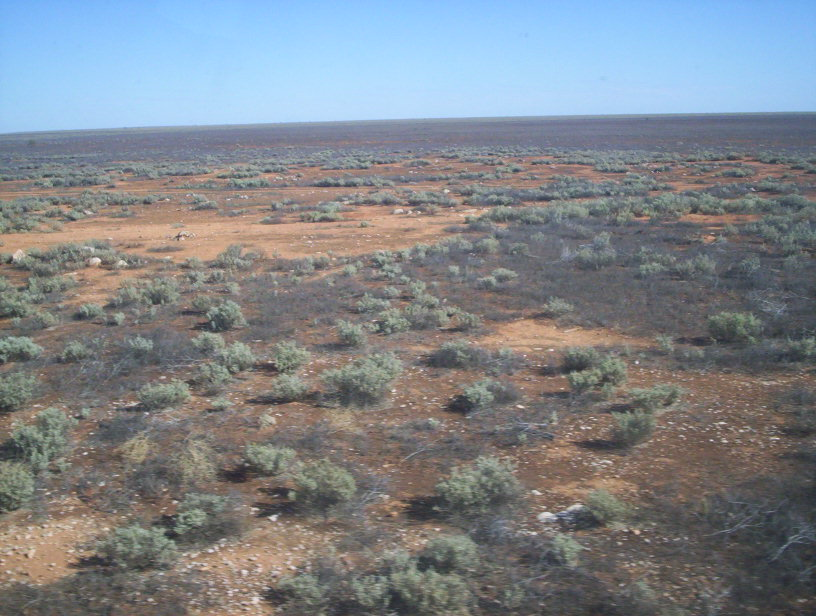
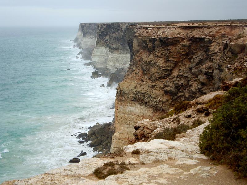
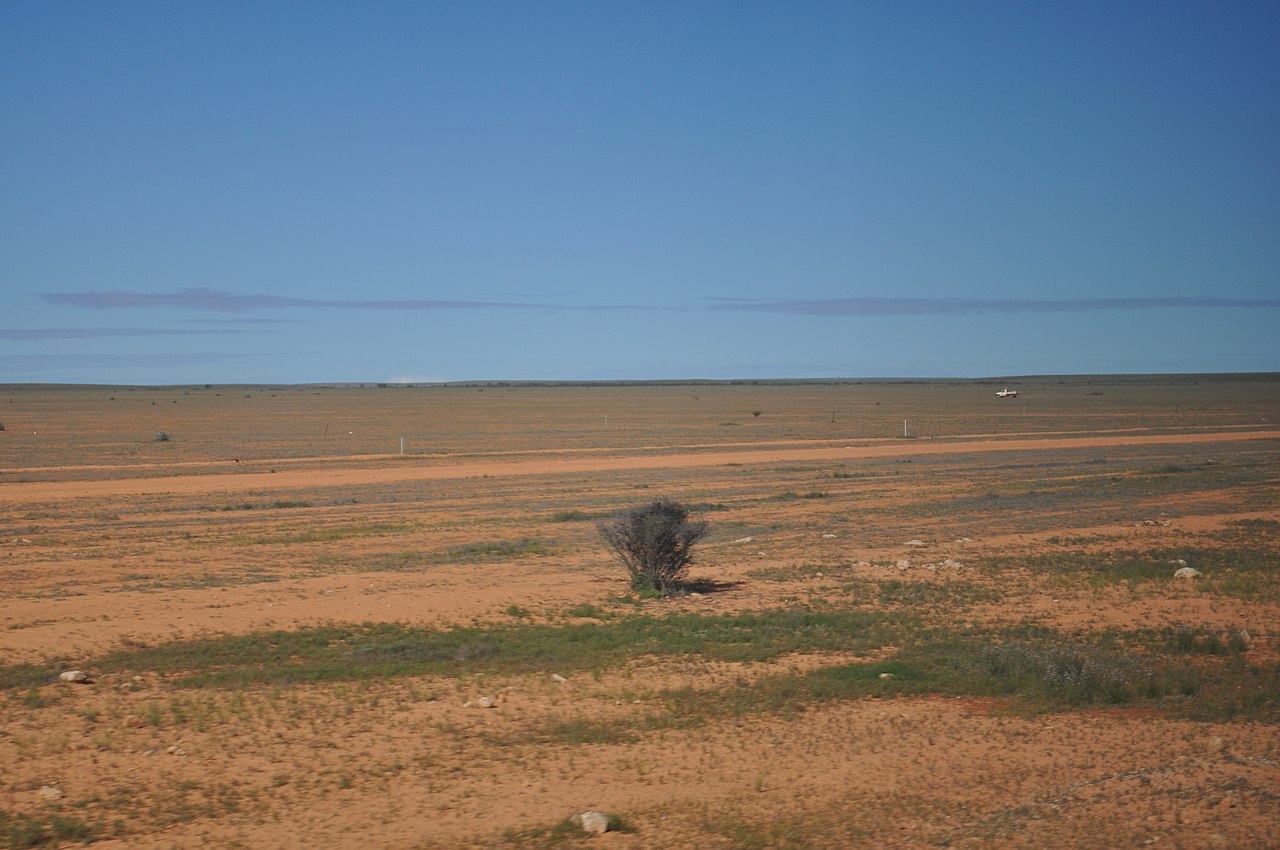
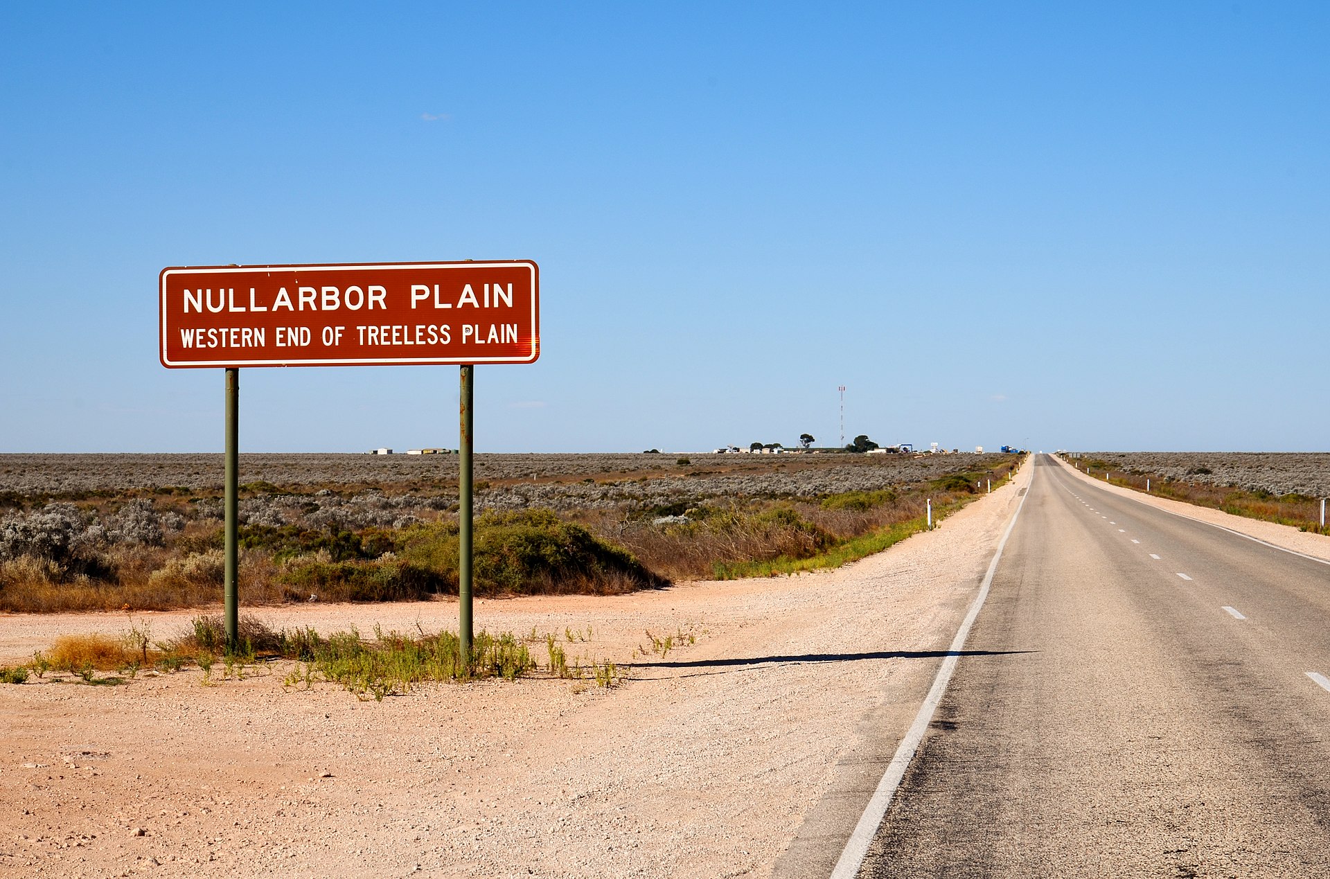
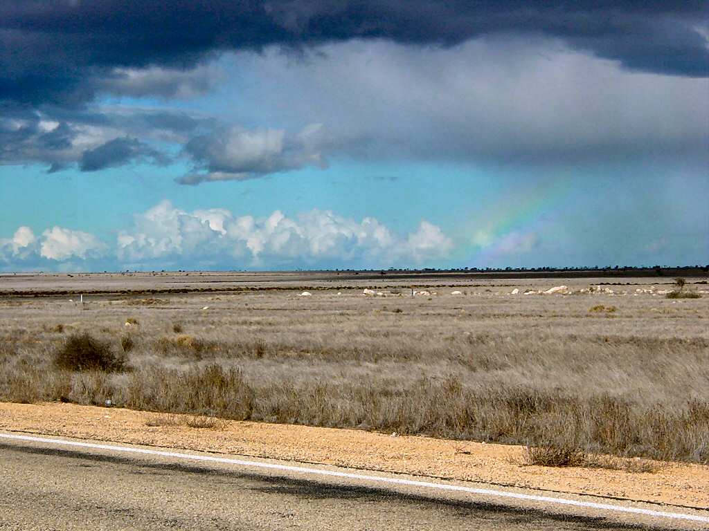
The 1,200-km coastline along the Great Australian Bight runs from approximately Ceduna in South Australia in the east to Esperance in Western Australia in the west. North of this coastline lies the Nullarbor Plain — Latin for “no trees,” reflecting the absence of significant tree cover across most of the 200,000-square-kilometer plain. The Nullarbor is the world’s largest single exposure of limestone bedrock — essentially a former seabed lifted from the ocean during the Miocene epoch (roughly 23 million years ago) and never since covered by significant erosion or new sediment.
The coastline itself is dramatic. The Bunda Cliffs (also called the Nullarbor Cliffs) extend for 220 kilometers along the eastern portion of the coast. The cliffs rise 60 to 120 meters (200-400 feet) directly from the Southern Ocean. Below them, the Southern Ocean rolls in waves that have traveled across thousands of kilometers of open water — among the longest unobstructed wave fetches anywhere on Earth.
For most of human history, the Nullarbor was inhabited only by Aboriginal peoples. The Mirning (“Whale People”) and Yinyila clans occupied the region for approximately 40,000 years, with sophisticated knowledge of water sources, food, and seasonal patterns. The Mirning called the area Oondiri — “the waterless.” Their occupation was seasonal and population numbers remained low because the land could not support dense human population without modern infrastructure.
European exploration began in 1627 when Dutch navigator François Thijssen sailed along the western margins of the Bight. The interior remained unknown to Europeans for two centuries. In 1841, Edward John Eyre became the first European to cross the Nullarbor by land — a journey that nearly killed him and his Aboriginal guide Wylie. Eyre’s expedition was saved only by Wylie’s knowledge of hidden rock holes containing fresh water.
After Eyre’s crossing, no European made serious settlement attempts for decades. By the 1870s, the Australian government needed a telegraph line linking the eastern colonies with Western Australia. Engineers ran a single wire across the Nullarbor with small repeater stations every few hundred kilometers. These weren’t towns — they were lonely outposts staffed by a handful of operators living on the edge of survival. Most have been abandoned.
The Trans-Australian Railway construction began in 1917, with two teams setting out from Kalgoorlie and Port Augusta and meeting in the center of the plain at Ooldea. The 1969 reconstruction (which produced the world’s longest straight section of railway — 478 km without a curve) created small support communities at stations along the line. These are essentially railway-maintenance towns rather than independent communities.
The Eyre Highway was carved across the continent in 1941, providing the first reliable road connection between eastern and western Australia. Today, an average of 700 vehicles cross the Nullarbor on the highway each day. A handful of roadhouses serve fuel, basic supplies, and accommodation to drivers — but these aren’t towns either. They’re business operations supporting the highway corridor.
The 4 reasons every settlement attempt has failed
The pattern of failed settlement reflects four specific geological, hydrological, economic, and ecological factors that converge in the Great Australian Bight in a way that defeats human settlement at scale:
1. There is essentially no fresh water
The Nullarbor receives between 150 and 250 millimeters of rainfall per year — about 6 to 10 inches. By comparison, Sydney receives about 1,200 mm annually. The rain that does fall mostly evaporates rapidly in the high temperatures (summer maxima regularly exceed 45°C / 113°F) and is absorbed by the porous limestone bedrock.
There are no permanent rivers anywhere on the Nullarbor. There are no lakes that hold water year-round. The only natural fresh water sources are:
- Subterranean cave systems in the limestone, some of which contain ancient groundwater
- Rock holes that briefly hold rainwater after rare rain events
- Coastal seeps in a few specific locations
None of these can support significant population. The cave systems hold limited water and are difficult to access. The rock holes dry quickly. The coastal seeps produce small, often brackish water flows.
Modern desalination could theoretically address this, but the energy costs of operating large desalination at scale across remote sites are prohibitive. Cities like Perth and Adelaide use desalination as supplemental water sources, but those cities are connected to broader water infrastructure. A Nullarbor city would need to produce essentially all its water through expensive desalination — and would still face the question of where the energy for that desalination would come from.
2. There is essentially no soil
The Nullarbor is solid limestone bedrock. The soil layer above the limestone is, in most places, only a few centimeters thick. According to the USDA classification system, the Nullarbor’s soils are classified as Aridisols — soils that develop in arid environments with limited organic matter and high mineral content.
This means agriculture is essentially impossible at scale. The minimal soil cannot:
- Support food crops requiring substantial root systems
- Hold the water required for crop growth
- Provide nutrients for sustained agriculture
- Develop the organic matter that supports productive farming
The fringe regions support some grazing operations — particularly Rawlinna Station (1 million hectares, the largest sheep station in the world) on the Western Australian side of the plain. But even these are marginally economic and require substantial supplementary feed during dry periods. Sheep stations are not the same as farming towns supporting general populations.
Without agriculture, any city on the Nullarbor would need to import essentially all food from elsewhere. The transportation costs would make food prices substantially higher than in coastal cities — and would make any non-essential population economically irrational.
3. There is no economic reason to be there
Australia’s eastern and western coastlines support cities because those locations have specific economic advantages: ports for international trade, agricultural hinterlands producing exports, manufacturing centers serving domestic markets, financial services anchored by population concentration.
The Great Australian Bight has none of these advantages:
No ports. The coastline consists primarily of cliffs (the Bunda Cliffs) and beaches without protected harbors. There are no natural deepwater ports anywhere along the 1,200-km stretch. Building artificial ports would be extraordinarily expensive and serve no obvious commercial purpose, since:
No exports. The hinterland produces essentially nothing exportable. The grazing operations are limited. Mining occurs but is concentrated in specific locations (mostly in the Goldfields region of Western Australia, north of the Nullarbor) and produces only specialty exports rather than bulk commodity volumes.
No domestic market. The handful of permanent residents don’t constitute a market large enough to justify substantial infrastructure investment. Any business locating on the Nullarbor would face the same import costs as residents — making operations economically unattractive.
Mining is capital-intensive, not labor-intensive. Modern mining produces relatively few jobs per unit of capital invested. The mining operations that exist near the Nullarbor (BHP’s Olympic Dam in South Australia, various Western Australian gold and iron ore operations) employ comparatively small workforces and don’t generate the secondary economic activity that builds cities.
Tourism thrives on the void. The Nullarbor’s main tourist appeal is the experience of crossing it — the absence of development, the dramatic emptiness, the views from the Bunda Cliffs, the experience of “doing the Nullarbor.” Tourism doesn’t require cities; it requires roadhouses, modest accommodations, and the very emptiness that prevents urbanization.
4. The climate punishes prolonged habitation
Beyond the lack of water and soil, the Nullarbor’s specific climate makes long-term settlement physically demanding:
Extreme temperature swings. Summer days regularly exceed 45°C (113°F), with peak temperatures reaching 48.5°C (119°F). Winter nights frequently drop below freezing. The diurnal temperature variation is among the most extreme in Australia.
Wind exposure. The flat terrain offers no wind protection. The “Roaring Forties” winds that develop over the Southern Ocean reach the coast at full force.
Limited shelter. No tree cover means no windbreaks, no shade, no protection from sun, wind, or weather. Building shelter requires importing materials.
Geographic isolation. The nearest hospitals, specialized medical care, schools above primary level, and other essential services are hundreds of kilometers away. Emergency response times in case of medical emergencies, accidents, or natural disasters are necessarily long.
Aboriginal nuclear test impacts. The British nuclear tests at Maralinga in the 1950s rendered substantial portions of Aboriginal traditional territory uninhabitable for decades. Compensation has been provided to affected Wangai people, but the tests reinforced the perception that the Nullarbor was “empty land” suitable for purposes other than habitation.
What actually exists across the 1,200 kilometers
The settlements that do exist along this stretch tell a specific story about what’s possible in the region:
Ceduna, South Australia (population ~3,500). The eastern gateway. Functions as a regional service center for surrounding agricultural areas (the Eyre Peninsula, which is more habitable than the actual Nullarbor). Has hospital, schools, and other essential services. Outside the actual Nullarbor zone.
Esperance, Western Australia (population ~13,000). The western gateway. Coastal town with reasonable agriculture in surrounding areas. Major port. Outside the actual Nullarbor zone.
Cook, South Australia (population 4 in 2009). A railway support town along the Trans-Australian line. Currently maintained primarily for railway operations, with population fluctuating based on maintenance crews. Located along the world’s longest straight stretch of railway. Effectively a ghost town.
Eucla, Western Australia (population ~50). A small settlement near the South Australia border, primarily serving the highway corridor. Includes a roadhouse, motel, and minimal services.
Various roadhouse settlements. Border Village, Mundrabilla, Madura, Cocklebiddy, Caiguna, Balladonia, and Nullarbor Roadhouse all serve highway travelers. Each has 5-50 permanent residents staffing roadhouse operations. Not towns in any meaningful sense.
Tarcoola, South Australia. Former gold mining town, now maintained by railway maintenance crews. Population fluctuates around 100, mostly transient.
Ooldea, South Australia (effectively abandoned). Former water-source location. Was important during construction of the Trans-Australian Railway. Currently has essentially no permanent population.
The total permanent population across this 1,200-km coastal stretch and its hinterland is, depending on how you count and what you include, somewhere between 50,000 and 100,000 people. The actual Nullarbor coast itself, excluding gateway towns, has fewer than 1,000 permanent residents.
How to actually visit
For travelers interested in seeing one of the most dramatic uninhabited landscapes on Earth, the practical logistics are straightforward but require planning:
By car (Eyre Highway). The most common approach. The full crossing from Adelaide to Perth takes 3-4 days minimum, with overnight stops at roadhouses or campsites. Distance is approximately 2,700 km. Fuel must be planned carefully — gas stations are 100+ km apart in some sections. Expect to pay 50-100% premium on fuel prices compared to capital cities.
By train (Indian Pacific). The Indian Pacific weekly passenger train crosses the Nullarbor from Sydney to Perth (or vice versa). The 4-day journey includes the legendary 478-km straight section of track. Tickets range from $1,500 AUD (basic seats) to $7,000+ AUD (premium suites with all-inclusive food and beverage). The railway view of the Nullarbor is more impressive than the highway view.
By air. Charter flights and small commercial flights connect roadhouse airstrips with major cities. Useful for visitors with limited time who want to see specific sections.
Best viewing locations. The Bunda Cliffs lookouts provide the most dramatic views, with the Nullarbor National Park section offering the best access. The Head of the Bight viewing area is excellent for whale-watching during winter (May-October), when southern right whales migrate to the Bight to calve.
When to visit. April-October provides the most pleasant temperatures. Avoid December-February heat. Whale watching peaks June-September.
Time required. Allow at least one full day for crossing the most dramatic sections. Two-three days enables more thorough exploration of cliff lookouts, caves, and roadhouse stops.
What this all reveals about modern geography
The Great Australian Bight is a useful case study in how modern technology has not overcome ancient geological constraints on human settlement. With unlimited resources, you could build a city on the Nullarbor — desalination plants, imported food, helicopter medical services, climate-controlled buildings, transportation infrastructure. But the resources required would be vastly out of proportion to any benefit gained from the location.
The specific combination of factors — limestone bedrock preventing agriculture and water retention, lack of natural ports preventing trade, distance from population centers preventing efficient logistics, and climate extremes punishing prolonged habitation — represents what geographers call a “negative location” for urban development. Other negative locations exist (the Sahara interior, the Antarctic continent, certain Arctic regions), but few combine all the specific factors that the Great Australian Bight does.
Modern infrastructure has reduced the practical effects somewhat. The Trans-Australian Railway and Eyre Highway have made crossing possible. Telecommunications have eliminated the absolute isolation of earlier eras. Modern roadhouses provide reliable services for travelers. But none of these technologies has overcome the fundamental geological constraints. The Nullarbor remains uninhabited not because of historical accident or cultural preference but because the physical landscape itself prevents the development that would otherwise occur.
For visitors, this produces something specific that doesn’t exist in most modern travel destinations. The Nullarbor is genuinely empty in ways that have substantially disappeared from most of the developed world. The 1,200-km coastal stretch contains essentially no light pollution, no urban noise, no signs of population beyond the occasional roadhouse or passing vehicle. Standing at the Bunda Cliffs at dusk, watching whales surface in the Southern Ocean below while the sky transitions to the most extraordinary star fields most modern people will ever see, produces an experience of genuine wilderness that isn’t available in most “wilderness” destinations.
The reason nobody lives on this massive stretch of Australian coast isn’t mysterious. It’s geological, hydrological, economic, and climatic — four specific reasons that have defeated 200 years of European attempts to settle there and that continue to defeat any serious modern proposal to develop the region. The Aboriginal Mirning people knew the answer 40,000 years ago. They called it Oondiri — the waterless. The land hasn’t changed. Modern technology hasn’t changed it. The Nullarbor will likely remain essentially empty for as long as humans inhabit Earth — a permanent reminder that some places on this planet simply cannot support cities, no matter how much we might want to put them there.